2 On The Road Blog

After 12 years of full-time rving, we've sold our truck and trailer but we're still traveling. Email us at wowpegasus@hotmail.com if you would like to contact us.


Thursday, July 30, 2009

Mount Walker Viewpoint

Along the east side of Hwy 101 on the Olympic Peninsula, the Mt. Walker Viewpoint is reached by a windy, gravel road. We started at 800's in elevation and the viewpoints were at 2805'.

Course it's aways bad on a gravel road if someone is ahead of you kicking up the dust.

Due to the heat and bad air quality, the view was quite hazy. Here we are at the north viewpoint.


Then we headed over to the south viewpoint.


Fort Worden State Park

Fort Worden is a 443-acre park that was part of an important system of coastal fortresses guarding the entrance to Puget Sound.


This display showed the locations of the forts and how they covered the inlet. Sorry, Fort Worden got cut off at the bottom of the photo.


The following photos show the panoramic view from the fort. You can see Fort Casey on Whidbey Island.


You can just make out the tip of Marrowston Island, home of Fort Flagler, in this photo.


The Commanding Officer's Quarters was built in 1904 and is now a museum. Built in the Jeffersonian style, this nearly 6,000-square-foot house features a slate roof and decorated boxed cornices.


The Commaning Officer's Quarters is one of many Victorian houses along Officers' Row that line the parade grounds. The rest have not been restored to the extent that the COQ was but they are now rental units.


Love the oval windows.


All interior photos had to be taken without flash so we have a lot of blurry photos. We don't have photos of the living room but the fireplaces in it and the dining room were ordered from Sears along with the stove in the kitchen and the sliding pocket doors between the dining and living rooms.


None of the furniture is original to the house but it is period appropriate.


This bun warmer was built onto the steam heat register.


See if you can guess the five states.... I'll list them at the bottom of this post.


The washing was actually done in the basement of this home and the washing machine in the corner is just there for display purposes.


Sorry so blurry. This stove was purchased from Sears.


Notice the sweeper and the thin register.


This was originally a servants room but its function changed as the number of servants declined.
Servants were expected to keep up with the household mending and sewing so this room may have served an important function as a sewing room. The vintage Singer treadle sewing machine was a greatly appreciated piece of modern technology. The two white graduation dresses were proudly worn in 1900 (the white cotton) and 1914 (the beaded ivory).


That's a toilet with an elevated cistern and chain. Thanks Carol for making the photo lighter.


Look at the height of that headboard!


Next we went down to the Marine Science Center but it was closed. Since the temperature was in the 80's, the water was full of swimmers.


Nolan was fascinated by this bathing beauty. She sure loved the water.


Looking off the dock, we saw the water was full of jellyfish. A local told us they were harmless.


So have you guessed the five states yet? They are Alaska, Hawaii, Oklahoma, Arizona and New Mexico.


...We were going to stay in Port Angeles the first night of the trip but the temperature was in the 90's and the hotel we had picked didn't have air-conditioning. We ended up in Sequim at a hotel with a/c.

Olympic National Park - Part 1

Upon entering the park, we were given a paper called the Bugler, the Olympic National Park newspaper and most of the following commentary comes from that publication. Established in 1938, Olympic is home to over 3,500 miles of rivers and streams that provide habitat for 29 species of native freshwater fish. Three hundred bird and 70 mammal species call this place home.
ONP occupies most of the interior of the upper portion of the Olympic Peninsula and some of the coast line. Most of the 923,000 acres that comprise the park is designated wilderness area.

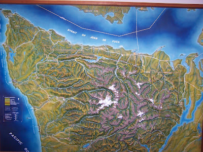
Our trip started with a drive up to Hurricane Ridge. Along the way we stopped at this viewpoint where we could just make out the Strait of Juan De Fuca and the shoreline of Vancouver Island. See map below to visualize what we might have seen on a clear day. Washington was experiencing a heat wave and air stagnation that resulted in the hazy view. The next three photos can be combined to show the panoramic view we saw.


This viewpoint was right before a series of three short tunnels.


The hazy view from the visitor center.


This map shows the names of the peaks in the photo below.


This map names the peaks in the photo below.


This map names the peaks in the photo below.


There were many trails around the visitor center but we picked a short one since we had a full day planned. We hiked the High Ridge Trail and part of the Cirque Rim Trail. We have friends that recently hiked to Klahhane Ridge and up the Switchback Trail.


The trail started off paved.


Since the park service had so kindly labeled the flowers for us, we decided to do a little flower-sniffen'.


A fellow trail walker pointed out this small bird, maybe a baby quail, and the mother bird in the tree that was upset over us being near her chick.


Here's where the trail turned to dirt.


From here we looked down and could see the road we traveled to the top.


Once we got to the top of the first peak, we could have continued the hike to Sunrise Point but instead, we headed down.


Even in a park drenched by 12' of rain a year, the summers are dry. When lightning strikes, small fires spread. This creates a natural patchwork of burned and unburned meadows, forests and silver snags like those at Hurricane Ridge. In September 2003 lightning ignited a fire near Griff Peak, two miles from the spot where this photo was taken. It was too dangerous for firefighters to dig a fire line on the steep slopes, amid falling trees and rocks. Instead crews used sprinklers, helicopter water drops and bare ridges to halt the fire's spread.


October rains had the final word, extinguishing embers that lingered in the 820-acre Griff fire.


During the drive back down the mountains, we stopped to do some more flower-sniffen'. Looks like these wildflowers are holding some soil on the steep slopes.


The orignial planned called for us to stay at a cheap hotel in Forks for the night but that hotel didn't have air-conditioning and the temperature was 91° when we passed through the town. We ended up in Hoquim where the fog had moved in and the temperature was 61° at 8 pm. One of the coolest temperatures we had see all day. It was 79° when we left Sequim at 7:27 a.m.