
 |
| We decided to take a two-day trip down the coast to see some things we hadn't seen before and revisit some that were interesting. The first stop was just north of Coos Bay at Horsfall Beach. One of the General Warnings is "Watch of Sneaker Waves". Never heard of them before coming to Oregon but they snatch a lot of people off the beach every year. |
 |
| We were stopping to see the shipwreck on the beach that can be seen at low tide. We had a negative tide so we figured it would be a good time to see the wreck. I don't see a boat/ship, do you? |
 |
| Ok, it's just a few pieces - a true shipwreck. This was the piece closest to the water. |

 |
| The boardwalk to the viewpoint was covered in lichen/algae/fungus. |

 |
| We dropped by Charleston to see the Charlie the Tuna sculptures by the bridge. This one has seen better days. |

 |
| Charleston is between Coos Bay and Cape Arago. We kept heading southwest toward Cape Arago. You can double click on any photo to enlarge it. |
 |
| We stopped at Simpson Reef. |

 |
| Between Charleston and the end of the road, there are three state parks - Sunset Bay, Shore Acres and Cape Arago. Simpson Reef is between Shore Acres and Cape Arago |
 |
| View of the reef. |
 |
| On this closer shot, look at the tan colored spot with some black dots on it. |
 |
| Yes, this is a beach with seals and sea lions on it. |


 |
| North viewpoint at Cape Arago. |
 |
| Zoom in on some of the shore features. |

 |
| Back at the parking lot, we were greeted by this raven. |
 |
| Next stop - Bandon. This sculpture of a rockfish is made totally of debris that had washed up on the beach. |


 |
| My Finnian, what a big mouth you have. |


 |
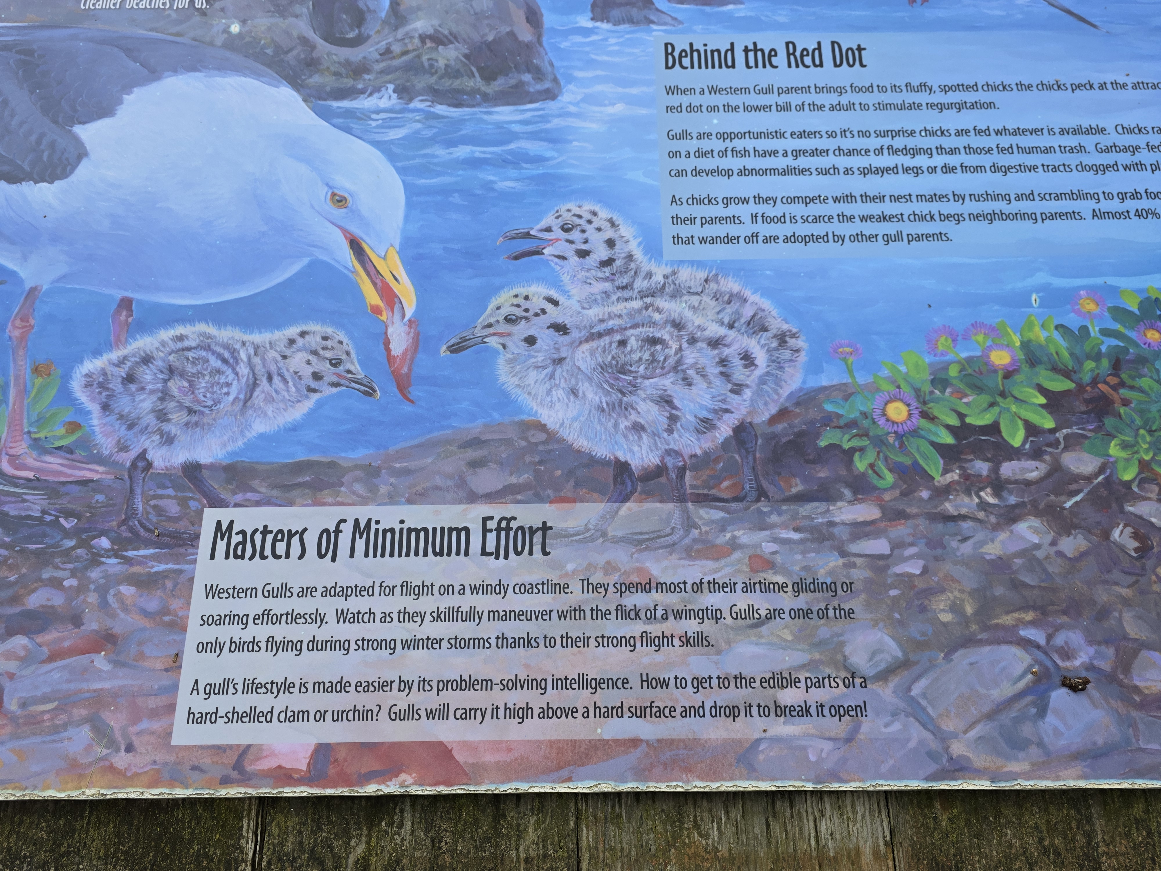
| Very interesting! So help the kelp forest, order purple sea urchins when you eat out in this area. |


 |
| Next stop - Coquille Point |


 |
| Another Washed Ashore sculpture. Less than 1/2 the size of the rockfish. |


 |
| Elephant rock. I suppose the rock between the two openings could be a trunk. |

 |
| This display is worn. The following photos are closeups of part of it. |


 |
| How interesting.. |

 |
| North Coquille Point Rock |
 |
| Table Rock |
 |
| Moving in for a closer view of Table Rock. |
 |
| Closer yet we can start to identify birds. |
 |
| This windy day made it very difficult to get a clear photo of the birds on top of Table Rock. I would have needed a tripod to get a clear shot at this zoom level. |


 |
| The grass covered dunes had quite a few clumps of iris growing on them. |

 |
| Next stop - Cape Blanco Lighthouse |
 |
| This was the windiest spot we went to all day! Still cloudy with some sprinkles. See the lighthouse in the middle left? Anyone wanting to visit the gift shop at the lighthouse would have to walk there. We declined. |
 |
| Straight from Wikipedia "In a deed recorded in 1867, John D. and Mary West sold the United States a 47.3-acre (19.1 ha) tract of land. The Light-House board determined that the offshore reef and islands at Cape Blanco were dangerous to maritime commerce; therefore, a lighthouse was authorized for construction. Over the next three years, the lighthouse was constructed under the direction of Lt. Col. Robert Stockton Williamson. Supplies were ordered and shipped to the cape. Bricks were deemed cheaper if made onsite, so a brickmaker was located and a deal was struck with Rancher Patrick Hughes for access to the required materials." |
 |
| I didn't see a name for this pinnacle of rock at the shoreline. |


 |
| We stopped for the view south of Port Orford when I noticed what looked like shark fins projecting from the surface of the water to the left of the rocks. |
 |
| No, no colossal sharks, just interesting rock formations. |
 |
| Next stop - Gold Beach. |


 |
| You might have to double click on the photo so it will enlarge for reading. |


 |
| Further along the port we saw this sculpture of a salmon fisherman. |
 |
| Just thought the flowers made for a nice photo. Just to the left is a bunch of jetboats that are used to take people up the Rouge River. |
 |
| Next stop the lower harbor at Brookings. |

 |
| Interesting history. |
 |
| Coming home from a day of fishing. |
 |
| Our last stop of the day is Oregon Redwoods Trail. This is south of Brookings, 8 miles from Hwy 101. Five miles of it is one-lane, gravel with the last three miles deeply rutted. A passenger car or SUV would not have been able to navigate the craters in the road. |

 |
| Pictures do not show the scale of these huge trees. |


 |
| The first part of the downhill side of the trail was supported by logs. |


 |
| Look at the size scale at the top of the photo. Redwood cones are tiny. |


 |
| Large burl on a tree. |
 |
| Twins! |
 |
| This redwood has been horizonal so long it has become a nurse log with a full-sized regular tree growing out of its side. |
 |
| A fallen tree suspended above the road. |
 |
| Deep rut and log sticking out from the bank. |
 |
| Sometimes the foliage made the road less than a vehicle wide. |

 |
| Deep, deep washed-out road troughs. |
 |
| We stayed the night at the Curly Redwood Lodge in Crescent City, CA. Now I never usually post anything about when we stay but this place is unique. Notice the spread-out U-shape. |
 |
| Sign at check-in desk. Better information on their website www.curlyredwoodlodge.com |
 |
| Relative of the lodge builder in front of the log in 1952. |
 |
| The shape of the lodge makes for an interesting, staggered room layout. |
 |
| Redwood is used for each door and its surrounding. |
 |
| Parking spots are divided with curly redwood pillars. |
 |
| Beautiful, huh? |
 |
| Close up of door. |
 |
| The next day we headed back north on Hwy 199. We had been down this with our truck and 5th wheel camper back in 2013. Many of the trees are close to the road and at least one of them has a little carved out of it so that it is off the road. |
 |
| The redwoods are only close to the road on the southern portion of the route. Here we are still on Hwy 199, but a stream runs alongside the road in a deep ravine. |
 |
| Our only sight-seeing stop on the way north was the Siskiyou Smokejumper Musuem by Cave Junction. |
 |
| There were lots of informational signage outside the building, so we didn't bother to call someone to give us a tour. |


 |
| Looking down the runway on the other side of the fence. |

 |
| A little yellow plane was doing touch-and-goes. |
 |
| It didn't have doors |


 |
| Look at the size of that cone hanging over the truck. |
 |
| This species can have cones up to 12" long. |


 |
| Quite the graph. Double click to read. |


