2 On The Road Blog

After 12 years of full-time rving, we've sold our truck and trailer but we're still traveling. Email us at wowpegasus@hotmail.com if you would like to contact us.


Tuesday, April 24, 2012

Mesa Verde National Park


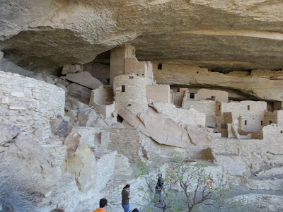
The internet was so bad at the park where we were staying that it took me four hours to put these photos online.  Now that we have a better internet connection, I can finish the post.  This is the Cliff Palace cliff dwelling.  One of the largest of the 600 in the park.  Now the info from the park brochure.  "Mesa Verde National Park was created in 1906 to preserve the archeological heritage of the Ancestral Puebloans, both atop the mesas and in the cliff dwelling below.  The park includes over 4,500 archeological sites; only 500 are cliff dwellings."
 
  
Double click to read this photos caption.

This is a photo from across the canyon.


You have to pay to take this 1 hour tour led by a ranger.  The path leading to the dwelling has a gate to keep people from wandering around on their own.


There is only one ladder on the way to the dwelling.


From the park brochure, "About 1,400 years ago, long before Europeans explored North America, a group of people living in the Four Corners region chose Mesa Verde for their home.  For more than 700 years they and their descendants lived and flourished here, eventually building elaborate stone communities in the sheltered alcoves of canyon walls.  Then, in the late 1200's, in the span of a generation or two, they left their homes and moved away.

Using nature to advantage, Ancestral Puebloans built their dwellings beneath the overhanging cliffs.  Their basic construction material was sandstone that they shaped into rectangular blocks about the size of a loaf of bread.  The mortar between the blocks was a mix of dirt and water. 


Living rooms averaged about six feet by eight feet, space enough for two or three persons.  Isolated rooms in the rear and on the upper levels were generally used for storing crops.  They were experienced builders, as the construcion testifies.  Walls are tall and straight and have withstood the tests of time and the elements."


Our guide told us that there were stone buildings on the mesa tops also but, because they weren't sheltered from the weather like the cliff dwellings, they just looked like mounds of dirt to the first archeologists to discover them.  He also said that the cliff dwelling were the least desirable dwellings of the Ancestral Puebloans and were built because land on the tops of the mesas was taken with crops and other dwellings.  They estimate that the mesas were home to around 5,000 people.


We looked up one of the towers.  The floors, except for the juniper beams, are gone and you can see art work on some of the walls.  I saw this design and the one in the next photo.


What looks like windows are actually the entry ways.  Ladders on the outside lead up to the different levels.  The walls are plastered.  The outside walls were also plastered.


Every 1/2 hour a group of 50 is led to the dwelling.


We traversed lots of steps through narrow crevices on the way back to the top of the mesa. 

Nolan coming up the ladders we had to climb to get back on top.  The Ancestral Puebloans climbed the cliffs using small hand and toe holds they chiselled.


The following few photos are other cliff dwellings we saw.  This one's hard to see.


Double click to enlarge this info panel to read about Square Tower House, the tallest dwelling in the park.

Square Tower House.


Double click to enlarge to read about the next dwelling photos.


Spruce Tree House


The path to Spruce Tree House is all paved but steep in places.


Spruce Tree House again.

Some parts of the park had been engulfed in flames during the last decade.


The landscape in these parts were very barren.

Others were covered in juniper and pinyon pine


Double click to read


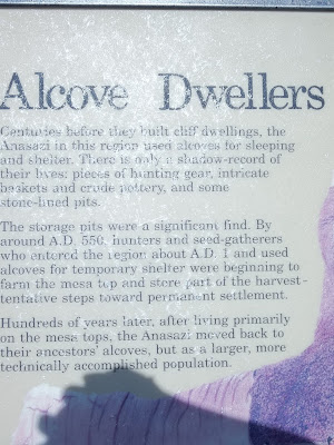
Pithouses were the dwellings most used around 550 A.D. when the mesa tops were starting to be inhabited.


Double click to read the info describing the next photo.


The highlight of Nolan's day was seeing coyotes.  We saw two white ones when we were eating lunch but didn't get photos.


Monday, April 23, 2012

Natural Bridges National Monument


From the NPS brochure: "In 1883 prospector Cass Hite wandered up White Canyon from his base camp along the Colorado River.  In search of gold, he found instead three magnificent bridges water had sculpted from stone.  In 1904 The National Geographic Magazine publicized the bridges, and in 1908 President Theodore Roosevelt established Natural Bridges National Monument, creating Utah's first National Park System area. 

Several names have been applied to the bridges. First named President, Senator and Congressman in order of height, the bridges were renamed Augusta, Caroline, and Edwin by later explorer groups.  As the park was expanded to protect nearby Puebloan structures, the General Land Office assigned the Hopi names Sipapu, Kachina, and Owachomo in 1909.


Sipapu means "the place of emergence," an entryway by which the Hopi believe their ancestors came into this world.


Millions of years ago these sandstones were deposited and then slowly uplifted as part of the Colorado plateau.  Erosional forces gradually created today's canyons and landscpae. 


Kachina is named for rock art sysmbols on the bridge that resemble sysmbols commonly used on kachina dolls.


Owachoma means "rock mound," a feature atop the bridge's east abutment."


Due to an injured knee, this is the only bridge we hiked to because it has the easiest hike.   It is the smallest in both height (106') and span (180') of the three bridges.


The hike to the bridge was pretty easy to moderate.


Nolan worked hard to make sure it didn't fall while we were there.


If you walk under the bridge and go either right or left, you will find green pools of water. 

Sitting in the shade under the bridge.


From the other side.

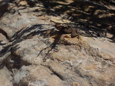
Nolan finally got a lizard to sit still long enough to take a picture.

The trail back to the trailhead at the top of the rise.


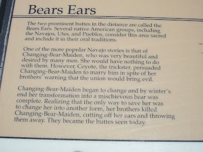
On the way out of the park we stopped to read this sign.


The Bear's Ears


As we drove east toward Blanding, we went through this huge cut in the bluff.  I bet it's 100' deep.