
 |
| We camped at Wahweap Campground in the Glen Canyon National Recreation Area. This photo is take from the rear of our fifth-wheel looking out over Lake Powell. |
 |
| But even better is the view from the roof of the fifth-wheel. |


 |
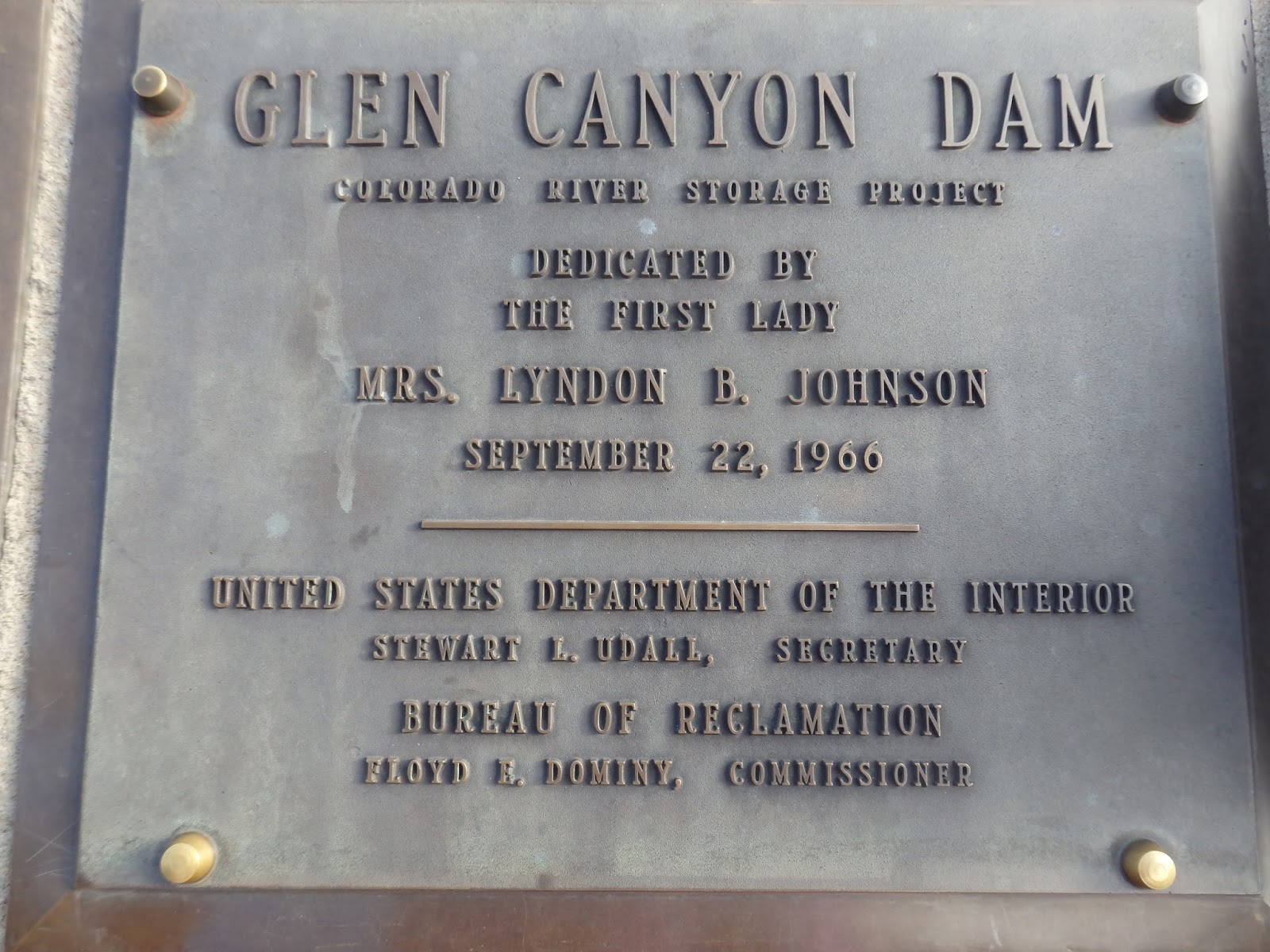
| Then we ventured out to the Glen Canyon Dam and bridge. From Wikpedia "Glen Canyon Dam is a concrete arch-gravity dam on the Colorado River in northern Arizona, United States, near the town of Page. The 710-foot (220 m) high dam was built by the U.S. Bureau of Reclamation (USBR) from 1956 to 1966 and forms Lake Powell, one of the largest man-made reservoirs in the U.S. with a capacity of 27 million acre feet (33 km3). The dam is named for Glen Canyon, a series of deep sandstone gorges now flooded by the reservoir; Lake Powell is named for John Wesley Powell, who in 1869 led the first expedition to traverse the Colorado's Grand Canyon by boat. In addition to its flooding of the scenic Glen Canyon, the dam's economic justification was highly questioned; with what critics saw as unnecessary damage to the wilderness, it became "a catalyst for the modern environmental movement," and was one of the last dams of its size to be built in the United States. The dam has been criticized for the huge evaporative losses from Lake Powell and its heavy impact on the ecology of the Grand Canyon, which lies downstream; environmental groups continue to advocate for the dam's removal. Water managers and utilities state that the dam is a major source of renewable energy and provides a vital defense against severe droughts." |
 |
| This photo shows the lake side of the dam, the bridge and the power lines running from the power generation plant. |
 |
| Inside the Wahweap Visitor Center Click to enlarge for reading. |


 |
| We wandered outside to look down at the dam and power plant. |


 |
| Wikipedi info. "The Glen Canyon Bridge or Glen Canyon Dam Bridge is a steel arch bridge in Coconino County, Arizona, carrying U.S. Route 89 across the Colorado River. The bridge was originally built by the United State Bureau of Reclamation to facilitate transportation of materials for the Glen Canyon Dam, which lies adjacent to the bridge just 865 feet (264 m) upstream. The two-lane bridge has an overall length of 1,271 feet (387 m) with a deck 700 feet (210 m) above the river and was the highest arch bridge in the world at the time of its completion in 1959." |

 |
| You can see the power generating station at the bottom. |

 |
| Looking back upstream and the start of Lake Powell |


 |
| We watched one of many different films showing in the visitor center. |
 |
| Next we walked out to the bridge. Here's one set of power lines and towers heading away from the power generating plant. |
 |
| Looking downstream of the dam. |
 |
| The Wahweap Visitor Center perched over the lake, river and dam. |
 |
| Next we headed on down the road to the dam overlook. Most of the time the only way you could tell where the "trail" went was by following the fence. |
 |
| Wouldn't want to try this when it was wet. |
 |
| Aw, steps make walking easier. |
 |
| Downstream side of the dam. You can see a semi going over the bridge... What? You can't see it? |
 |
| Does this help? |
 |
| Looking down the river. Nolan noticed a trail. |
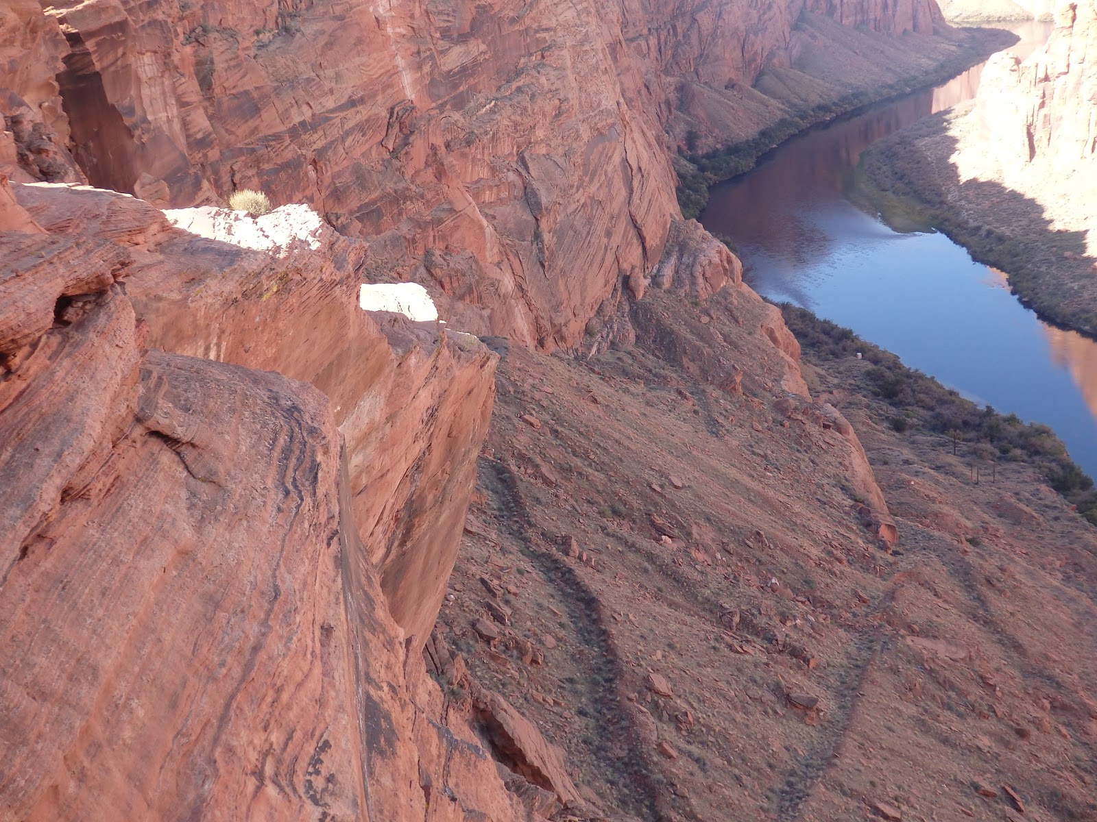 |
| You can see the trail easier in this photo. |
 |
| Some gal saw a roadrunner and it was hard to get a shot of because it kept moving. |

 |
| In case you can't read it, here's the wording from this sign, "Why are two power plants so close to each other? The river is the answer. Glen Canyon Dam created Lake Powell from the Colorado River. At the base of Glen Canyon Dam, water pushes through the turbines to create electricity. At the Navajo Generating Station coal heats water into steam and the steam spins the generators, then exits through the cooling towers. The availability of water at Lake Powell, the proximity of a source of coal, and a worker base in the city of Page, Arizona determined the location of the Navajo Generating Station. |
 |
| You can see the Navajo Generating Station in the distance. |
 |
| Here's what this sign says, "You may think you have no connection to the Colorado River. But every person in America is connected to the Colorado River. How can that be since drinking water and electricity from the river only serve the Southwest? The answer lies in the question, "Where does my salad come from in the wintertime?" The river is the answer. The greatest percentage of the water from the Colorado is used for agricultural purposes - namely, irrigation of California farmlands. This use provides one-third of America's fresh fruits and vegetables year-round. But the river is already over-allocated. Water conservation is essential to the quality of life everywhere. No matter where you live, if you enjoy a garden salad in January, conservation helps ensure the Colorado River will run through it." A lot of lettuce, cabbage, spinach and other vegetables are also grown around Yuma, AZ utilizing water from the Colorado. The Central Arizona Project is a canal that gets water from the Colorado and distributes it across Arizona. Some is used to grow cotton in the Casa Grande area. |


No comments:
Post a Comment