
 We had three days off so we decided to take a trip. First we went south to drive SR 14 along the Washington side of the Columbia River Gorge.
 Last week we visited Vista House. This week we are looking at it from the Washington side. See how it's perched on a cliff. The road actually goes around it.
The next three photos are from the same point . Start with this one and the next three are actually to the right of the first.


It's a cloudy day so the view isn't as good as it would be if it was sunny.


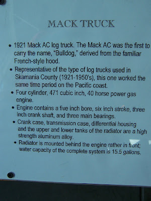
This is the first time we had ever seen a sign like this.

I spotted this eagle on a branch as we passed by and I walked back to get a photo. I got one and then it flew away.
 We forgot to get a photo of Beacon Rock but we climbed it.

Purchase price was $1.

 Pretty nice trail as we started our climb
Nice rock wall.

Oh boy it looks like the trail is about to get a LOT steeper!

Part of the trail was dirt, some was asphalt and some concrete. Some bridges were made of concrete and some were made of wood. Is the climb making you tired yet?
 A look at the river part way up the trail.
 What about now?
 We were tired and sweaty by the time we made it to the top. I just wished it had been sunnier so the view would have been nicer. Well then it would have been hotter, huh? Maybe not.
Somee photos from the top.

More about how high the great pre-historic flood would have been. Above the pictures is this caption, "Imagine standing here 15,000 years ago. A thunderous roar fills your ears. In the distance, a torrent of mud and ice hundreds of feet high bears down on you at 60 mph."
 Nolan using the fence as a support.

Ok we head back down but this time I'm counting switch backs. See here how there are different surfaces. The top one here is very rough stones and it's the roughest spot we came across. The next is asphalt with a wooden bridge. On the way down we met a woman that said she used to live nearby. She told us that Mr. Biddle didn't use mules or any other animals to help him get all the supplies up the rock. I'm surprised it didn't take 10 years to build the trail!
 Double-click to enlarge this one and count the number of layers. There's a couple that switch to the left and cross under the upper tier. Our final count for the journey down the rock (if we counted right) was 51 turns of more than 90° and there are at least as many under 90°.
As we headed east on Hwy 14 we turned back to get this distance shot of Beacon Rock. It really doesn't show you how it sticks out from the other rocks.
 We passed by Bonnevile Lock and Dam.
Next we visited the Columbia Gorge Interpretive Center by Stevenson. The display for this model reads, "Launched at John Holland's Yards in Seattle, the Bailey Gatzert plied the Columbia each day leaving Portland at eight and docking at The Dalles at three, and returning to Portland at nine-thirty at night. The fare was one dollar."


 There was a large display of saws.


Look at those worn down solid rubber tires!


 Notice the heel rest.
 Only two gauges. Ours has 18 or 20!


 Notice the heel rest.
 Only two gauges. Ours has 18 or 20!


On display was the household contents of a Russian Baron's home. This Swiss cabinet of inlaid wood is approximately 200 years old and is the life's work of a craftsman.


Some of the cabinets detail.


American flag made out of rosaries.
 There were at least six cabinets full of rosaries! Must have been 4,000 of them!
My favorite
 After the museum we continued on our trip. Just some scenery.

Notice the rock wall along the road.
 Then notice the low rock wall on the right side of the road.

Then we started going through tunnels. Notice the train tunnel does have a fancy stone front.


Windsurfers by Lyle.
 Bridge from Dalesport to The Dalles, OR.
 Notice how the land is becoming drier. We're on the east side of the Cascades now.

We stopped at a rest area and got some nice photos. Notice the train in the middle left.
 The train went directly below the rest area!

Across the river you could see I-84 and more train tracks.


 While I was taking the previous photos, a train was headed eastbound on the opposite side of the river.

There are sometimes lakes between the road and the river or the road is between a lake and the river.
 The last tunnel we went through on hwy 14. Notice it is actually two tunnels with a short break in between.

Only the second barge we saw during the day. This one is heading upstream.

I was trying to get photos of the brown hills and took this one out the back driver's side window. Didn't know the deer were there until I downloaded the photos to the computer.


 We stopped at the Klickitat County Information Center and view point.

That's I-84 and the train tracks across the river again.


Mount Hood is hiding behind some clouds.
 The Maryhill Museum of Art was about to close when we got there so we didn't go inside.
 There were 6 or 7 peacocks roaming the grounds.

We did look at the sculptures.


Just look at how old tools were used to make this sculpture.


No this isn't a sculpture. Just a peacock posing. It was way too windy for any of them to have their tails spread.


The next stop was Stonhenge. No not the English one but a replica of how the original would have looked when it was intact. It was built in 1918.

There are plaques to honor WW II veterans on the inside of the inner walls.


A view from Stonehenge.
 The next stop was the Goldendale Observatory State Park. This is Mount Hood as seen from the park.
 Goldendale Observatory State Park where we peeked at stars. It was the wrong time of year to peak at the stars. It isn't full dark until almost midnight since summer solstice is just a few days away.
We ended this first day of our three day trip at Goldendale.
 There were at least six cabinets full of rosaries! Must have been 4,000 of them!
My favorite
 After the museum we continued on our trip. Just some scenery.
Notice the rock wall along the road.
 Then notice the low rock wall on the right side of the road.
Then we started going through tunnels. Notice the train tunnel does have a fancy stone front.


Windsurfers by Lyle.
 Bridge from Dalesport to The Dalles, OR.
 Notice how the land is becoming drier. We're on the east side of the Cascades now.
We stopped at a rest area and got some nice photos. Notice the train in the middle left.
 The train went directly below the rest area!
Across the river you could see I-84 and more train tracks.


 While I was taking the previous photos, a train was headed eastbound on the opposite side of the river.
There are sometimes lakes between the road and the river or the road is between a lake and the river.
 The last tunnel we went through on hwy 14. Notice it is actually two tunnels with a short break in between.
Only the second barge we saw during the day. This one is heading upstream.

I was trying to get photos of the brown hills and took this one out the back driver's side window. Didn't know the deer were there until I downloaded the photos to the computer.


 We stopped at the Klickitat County Information Center and view point.
That's I-84 and the train tracks across the river again.


Mount Hood is hiding behind some clouds.
 The Maryhill Museum of Art was about to close when we got there so we didn't go inside.
 There were 6 or 7 peacocks roaming the grounds.
We did look at the sculptures.


Just look at how old tools were used to make this sculpture.


No this isn't a sculpture. Just a peacock posing. It was way too windy for any of them to have their tails spread.


The next stop was Stonhenge. No not the English one but a replica of how the original would have looked when it was intact. It was built in 1918.

There are plaques to honor WW II veterans on the inside of the inner walls.


A view from Stonehenge.
 The next stop was the Goldendale Observatory State Park. This is Mount Hood as seen from the park.
 Goldendale Observatory State Park where we peeked at stars. It was the wrong time of year to peak at the stars. It isn't full dark until almost midnight since summer solstice is just a few days away.
We ended this first day of our three day trip at Goldendale.

No comments:
Post a Comment