
 |
| We had flown to Melbourne so we could travel part of the Great River Road. We spent the night in Torquay and traveled as far as Port Campbell the first day. On the second we continued to The Grotto formation before turning around and hitting some of the stuff we had missed the day before. Click on map to enlarge. |
 |
| Only in Australia are you going to see warning signs about watching for kangaroo as you drove. |
 |
| Our first stop was the Split Point Lighthouse. When built in 1891, the lighthouse was originally called Eagles Nest Point. Although the majority of the lighthouse is concrete tower, all the metal parts had been manufactured elsewhere and brought in. It still has the original British-made, Chance Brothers first order lens. |
 |
| The lighthouse also has the nickname, "The White Queen". |
 |
| This is Bass Strait, the shallow ocean path between mainland Victoria, Australia and Tasmania. Wikipedia gives us the following information, "Bass Strait is a generally shallow (average depth of 50 m (160 ft)) stretch of water approximately 300 km (190 mi) wide and 200 km (120 mi) from north to south, encompassed by the entire northern coastline of Tasmania and Victoria's central to eastern coast. The prevailing winds and currents are westerly, the latter being divided by King Island, Tasmania at the western entrance to the strait, causing unpredictable sea conditions, especially when strong winds occur. For example, strong southerly winds can cause a strong northerly current reflecting from the Victorian coast. The combination of winds, currents, tidal flow and the shallow bottom often lead to tall waves, often of short length, with a confused short swell often conflicting in direction." The large dark spot on mainland Victoria is Port Phillip Bay. Melbourne is built on it's northern shore. Split Point lighhouse is halfway between there and the southern point to the west. |


 |
| Love this rendering of the depth levels of the area. Read about it on the previous photo. |
 |
| This poster showed the location of and information about some of the many shipwrecks in Bass Strait. |


 |
| Looking up at the underside of the staircase. |

 |
| Looking out a window during our climb to the top. |

 |
| The following photos are views from the top. |


 |
| Panoramic photo looking to the northeast |
 |
| The original lighthouse keepers' quarters, two detached houses adjacent to the tower, are now privately owned residences. |
 |
| Friendly spider ambling around the balcony didn't want to crawl into my hand. |

 |
| The only lens this lighthouse has ever had is still functioning |


 |
| This listing of the meanings of the maritime signal flags was interesting. |
 |
| There are different meanings when you combine flags. |


 |
| Testing rocket rescue apparatus in March of 1894. |
 |
| Breeches Buoy |
 |
| What the area around the lighthouse looked like in the late 1930's. |


 |
| In the popular Australian children's television series "Round the Twist", the Twist family lived in the lighthouse. |
 |
| Australia has a lot of lighthouses, and this is how they compare in size. |
 |
| We loved some of the flowers we saw on the way back to the car park. |
 |
| The birds liked them too. |

 |
| The original stables and work room, located to the right of this photo are now a cafe. |
 |
| As we continued our trip along the Great River Road, we saw that a home on the hill above the road had built an interesting observation room connected to the home by a covered walkway. |
 |
| Our next stop was the Memorial Arch south of Moggs Creek. |


 |
| There was also a walkway to the beach by the Memorial Arch, so we went down for a look. |
 |
| As I am known to do, I picked up a rock on the beach. |
 |
| My sister had also collected something and went to the water to wash it off. Well, she wasn't watching the ocean very well and a wave snuck up on her. She got a little wet. We had to use the hair dryer on her shoes that night. |
 |
| Looking back, we could see the Split Point Lighthouse. |
 |
| Further down the coast, we stopped at the North Lorne rest area and headed out to the beach. This beach looked a bit like the tessellated pavement we had seen in southern Tasmania. |


 |
| My sister spotted this field of birds as we got to the Lorne Jetty, so we stopped for a closer look. |
 |
| Sulphur-crested Cockatoo. Of about 330 parrot species that inhabit our planet, 56 are found in Australia. |
 |
| Galah is a more reserved and gentle bird than most Australian cockatoos. It is one of the most common cockatoos throughout Australia. |
 |
| Ocean watching as we made our way along the coast. |
 |
| View from Mount Defiance Lookout |

 |
There was a display panel at the lookout. It was about the life of a man named William Buckley. There are a total of 20 signs along what they call the William Buckley Discovery Trail that outline the life of this man. This is the only one we saw.  |

 |
| More ocean watching along the way. |

 |
| As we neared Kennett River, we saw a helicopter approaching. It was an air ambulance and it landed just a short distance in front of us. Traffic had been blocked but we were able to continue after just a short while. |
 |
| Kennett River was our stop because it was a known location for spotting wild koalas. This large koala was bellowing up a storm when we approached so it was easy to find. It was the only one we saw. |
 |
| We continued up Grey River Road for a while before coming back down. The helicopter was still there. |
 |
| Our next stop was Castle Cove Lookout. We saw this sign at the start of the walk. What caught my attention was the photo of the bird. |
 |
| As we were driving along, my sister mentioned that she had caught a glimpse of a red and blue bird. I assume this is what she saw. |
 |
| This is what the path looked like as I looked back toward the parking lot. |

 |
| Oh goody, more waves hitting rocks. |

 |
| The beach is a long way down there, but the sign did mention steps. |
 |
| Starting down... |


 |
| We had to take it slowly because the steps were wet and sandy. |
 |
| Almost down.. |

 |
| The cause for the puddle you saw in the previous photo. |
 |
| I'm not looking forward to going back up those. |

 |
| I found this on the beach. It is triangular, very light and |
 |
| has layers on three sides, one smooth, hard surface and a little rough on the final side. Part of baleen? |
 |
| Our last stop of the night was at Twelve Apostles to see the Australian Little Penguins some out of the ocean for the night. |
 |
| We left from the south side of the Visitor Centre, crossed under the road and continued on this path. |


 |
| The steps down to the first viewpoint. |


 |
| It was cold and windy as we waited for the Little Penguins to arrive. They generally appear between 10 and 15 minutes after sunset with their mass exit usually occurring 20 to 25 minutes later as twilight fades to dark. |
 |
| We enjoyed the view while we waited. |
 |
| I walked down the path but the other viewpoint was closed, so no penguin watching there. The penguins never showed up. I guess they make a lot of noise as they come back from their day in the ocean but we never heard them either. Bummers. |
 |
| The next day we continued past Port Campbell to the London Bridge viewpoint. |


 |
| Panoramic shot from the lookout. |
 |
| The furthest west we went on the Great River Road was The Grotto. |

 |
| The path was level as we started off. |
 |
| I believe this is called Carpobrotus, but commonly known as pigface or ice plant. |
 |
| Looks like our level path is starting to head downwards. |

 |
| Our first glimpse of The Grotto. Looks like a lot of steps. |
 |
| Still no steps but the angle is steep enough they have put in grip strips on the wood. |

 |
| The steps begin. |


 |
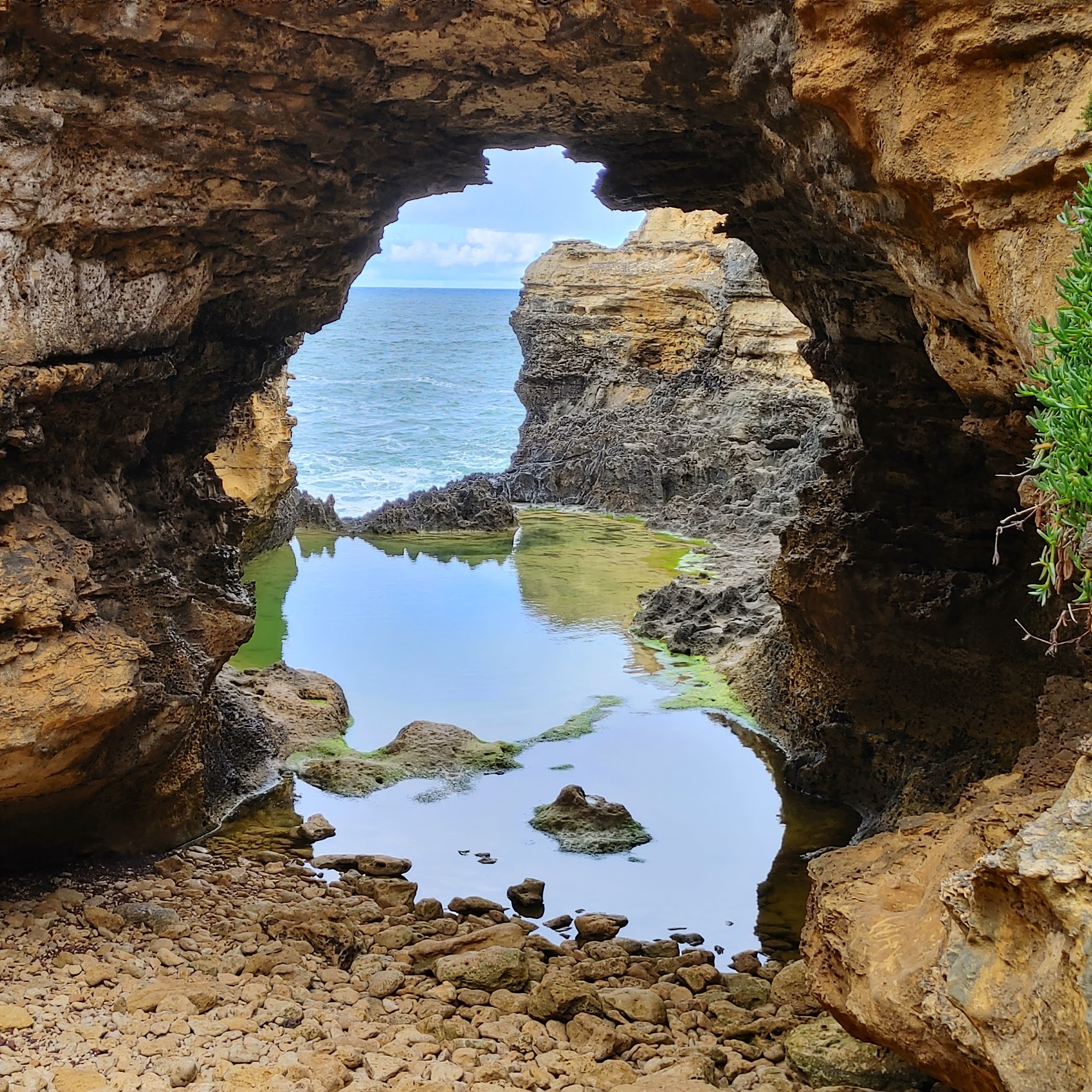
| Finally made it to the bottom and looked through the hole to the ocean. |
 |
| Watched the waves wash up the ledge on the far side and slide back off. |
 |
| Looks volcanic down there |

 |
| At first I thought the white patches on the grass were litter but, as I looked closer, I could see they were bits of foam. I figure they were egg sacks from some animal.?? |
 |
| Next stop Loch Ard Gorge. |
 |
| We first walked up the peninsula on the Shipwreck trail |


 |
| Panoramic shot from the viewpoint. |
 |
| You can definitely see the different layers of rock here. |
 |
| Another one of those snorkeled trucks. |
 |
| Island Archway viewpoint as we walked toward The Razorback |


 |
| What a dramatic viewpoint. |


No comments:
Post a Comment