


 |
| If you find any of the posts hard to read, just double click them to enlarge. |
 |
| We boarded a tour bus and headed to the beaches of Normandy. This photo is just to show you what road signs in France look like. |
 |
| So if I've done all the calculations right, using an exchange rate of 1€ = $1.16, the per gallon prices read, from top to bottom: $6.844, $7.157, $6.496 and $6.485. Now quit complaining about gas prices in the states getting to $4 a gallon. |
 |
| As we passed thorough Caen, we saw twenty bronze statues of the popular comic book character, Le Chat. Belgian cartoonist and humorist Philippe Geluck created this character in 1986. After Caen, the statues will continue their journey through different cities and countries. They will then be put up for sale to finance the Musée du Chat, which is due to open its doors in Brussels in 2024. |


 |
| You can double click to enlarge but the following photos show the brochure in smaller sections. |


 |
| Our first stop was Courseulles-sur-Mer, home of Juno Beach. |
 |
| Memorials remember the fallen Canadian and French forces who landed here. |
 |
| Once called the Cross of Anjou, this double-crossed cross is located on the border of the two communities of Courseulles-sur-Mer and Graye-sur-Mer. It is more that 59 foot tall and is located facing the sea. This monument commemorates the return of General de Gaulle to the soil of France on June 14, 1944 after crossing the Channel aboard the French destroyer La Combattante. |
 |
| Saw this interesting structure across the road from the cross but didn't know what it was. |
 |
| One of many bunkers that still dot the landscape. |
 |
| A British Churchill AVRE tank stands as a memorial of the landing operations. It was unable to bridge a deep culvert on D-Day one hundred yards south of the site and the members of its crew were obliged to escape under enemy fire with very heavy casualties. |

 |
| These structures in the water are part of the floating docks created by the British to create a supply line for the Allied troops. More on these structures later. |
 |
| At the memorial to the Royal Engineers, located close to Arromaches-les-Baines, stands an obelisk and some sections of the floating roads that connected the ingeniously constructed floating docks to the shore. |
 |
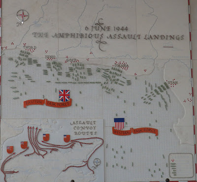
| This diagram shows the advance of the Canadian forces as the assault continued. |
 |
| This is a photo of the floating docks and bridges while they were in use. |
 |
| Closer view of the floating bridges |
 |
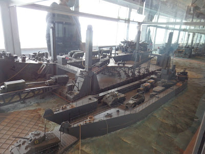
| Upon our arrival at Arromaches-les-Baines, we took a tour of the Musee de Debarquement - the Museum of Disembarking. In it was a huge model of the floating docks and bridges. |


 |
| The east pier shown here was essentially designed for the unloading of heavy vehicles. It was composed of two floating platforms assembled in a "T" shape. They were fitted with four big poles remaining on the seabed. They could then float up and down with the tide, sliding along the poles. Due to this clever system, ships, platforms and floating roads were always at the same level, which enabled continuous unloading, 24 hours a day. Thanks to this pier it took less than an hour to unload two large LSTs. LST is Landing Ship, Tank. |
 |
| Here you can see the poles down to the seabed. |
 |
| Empty lorries would reach the pier on the left floating road, they would be loaded on the platforms and then, they would go back to depots inland on the right floating road. |
 |
| This model is of the different kinds of "Phoenix" blocks used to build the seawall of the Arromanches Harbor. Built in Britain, these concrete monsters were towed across the Channel and sunk in position on the rocks off the coast. Today, out of the 115 blocks sunk here in 1944, only two dozen remain. |


 |
| Royal Air Force |

 |
| Flags of the participating allied countries are posted along the back side of the museum |
 |
| In front, a half-track M3 takes pride of place. |


 |
| A section of the floating road. |
 |
| Looking along the coast you can see some of the mulberry sections left. |


 |
| The steep cliffs along the coast were a huge obstacle for the forces to overcome. |
 |
| As the bus continued along the coast, it was often only one lane wide between homes in the old communities. |
 |
| Our next stop was the Normandy American Cemetery operated by the American Battle Monument Commission. The US is granted the use of the land as long as they maintain it. |
 |
| Looking down on Omaha Beach by Colleville-sur-Mer, France |
 |
| It is located on the site of the former temporary battlefield cemetery of Saint Laurent, covers 172.5 acres and contains 9,388 burials. |
 |
| The Memorial from the far side of the reflecting pool. |
 |
| The Memorial consists of a semicircular colonnade with a loggia at each end containing maps and narratives of the military operations. It is built in medium-hard limestone from upper Burgundy. Two of the maps, designed by Robert Foster, are 32 feet long and 20 feet high. |
 | |||
| At the center is a 22-foot bronze statue entitled The Spirit of American Youth Rising from the Waves by Donald De Lue. Over the arches of the Memorial is engraved "This embattled shore, portal of freedom, is forever hallowed by the ideals, the valor and the sacrifices of our fellow countrymen". At the feet of the Memorial is engraved, both in English and French, "In proud remembrance of the achievements of her sons and in humble tribute to their sacrifices this memorial has been erected by the United States of America". | . |
 |
| Double click to enlarge for reading. This is one of the many maps displayed in the Memorial |

 |
| Double click to enlarge for reading. |
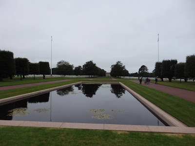 |
| Looking from the Memorial, across the reflecting pool to the Chapel |
 |
| All religious denominations are buried together. The Star is used for a Jewish person. |


 |
| We see more sections of floating bridge as we head to Omaha Beach. |
 |
| This is the site of the first American World War II cemetery. |
 |
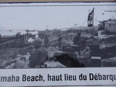
| A series of descriptive panels at Omaha Beach. Please double-click to read. |


 |
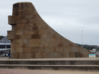
| The monument Les Braves is located in the center of Omaha Beach. |
 |
| Double click to read the description of Les Braves |


 |
| The simple granite pylon on a concrete bunker honors the men of the 2nd Ranger Battalion, who, using hooks, scaled the 100-foot cliff that was the site of the German's major coastal artillery battery. |
 |
| Double click to read the engraved message. |


 |
| Double click to see the engraving on the side of the monument. |
 |
| Glimpses of the Omaha Memorial Museum |


No comments:
Post a Comment