2 On The Road Blog

After 12 years of full-time rving, we've sold our truck and trailer but we're still traveling. Email us at wowpegasus@hotmail.com if you would like to contact us.


Tuesday, October 25, 2022

The Rocks

We started our first full day in Sydney with a walking tour of The Rocks.  The Rocks is an area of national historical significance. It was a site of Aboriginal occupation prior to the advent of the Europeans. It is the site of the first permanent settlement by Europeans in Australia and retains elements that illustrate aspects of the area's history from all periods of settlement to the present day.

The tour started at the Clock Tower

I found a few good websites while I was searching for information on The Rocks, but the best was probably, https://www.visitsydneyaustralia.com.au/the-rocks.html.
What an informative website!!  I'll mention which photos can best be described on the website by saying, "Go to The Rocks website".


Information on building in The Rocks is from the following website.
https://blogs.sydneylivingmuseums.com.au/cook/oyster-shells/
"Today our plaster is based on gypsum. In the 18th and early 19th centuries, however, plaster and stucco were based on calcium, the usual source of which was limestone, chalk or even marble (which unfortunately explains the disappearance of many a classical ruin over the centuries). In the very early colony, lime was a rare commodity and many builders complained that the poor quality of their mortar forced them to use simple clay instead; imagine the effect of a heavy Sydney thunderstorm on the buildings of the infant town.
In search of a local calcium supply – there is no limestone near Sydney – the colonists quickly turned to gathering shells. Exposed to high heat, the calcium carbonate in the shells collapsed into calcium oxide – or ‘quicklime’. This was then soaked in water overnight, prior to its use in mortar or in the stucco so characteristic of colonial Regency building. The whole process from gathering to slaking was hot and, considering how caustic lime is on unprotected skin, very unpleasant work for convict labourers. "
You can see the bits of shells in the mortar of this building.

Go to The Rocks website


The Suez Canal narrowed as it went downhill

Many of the building still had pulley hoists from the days when supplies were stored in the attic. 

The Nurses Walk.  What The Rocks Website had to say about it.
"Named by the Sydney Cove Authority in the 1970s due to the close proximity of the site of Sydney's first hospital, which operated from 1788 to 1816. On some early maps, it is marked as Cambridge Street.
The colony's first hospital was constructed here in 1788 and included a herb garden to help assist in treatment due to a shortage of drugs. The second hospital was a portable hospital which arrived with the Second Fleet in June 1790. The portable hospital was constructed in less than a fortnight and was soon filled with over 400 patients. Nurses were selected from convicts to work in the first roughly constructed hospitals."


Go to The Rocks Website to see what it had to say about the Reynold's Cottages. 

How the walkways were constructed.

Click to enlarge to read about Franis Greenway, convict architect who designed many buildings that are still standing in The Rocks. 

Timeline of some of the buildings he designed. 

More info on Francis Greenway. 


The Australian White Ibis is a more recent addition to the wildlife in Sydney.   They didn't start appearing until the 1970's.  Read more about it at, "https://sydneysentinel.com.au/2020/10/secrets-of-the-ibis-the-surprising-real-reason-bin-chickens-took-sydney-by-storm/"

Gannon House is an historic building designed and built by Michael Gannon from 1839 to 1840 as residential houses and stables.

The city has placed some informative signs along some of the main throughfares.  

Kendall Lane.  From The Rocks website under Laneways of the Rocks, "The name recalls the steam flour mill and biscuit factory of Lawrence Kendall which operated here from the 1860s (see Mill Lane above). Mill Lane was originally an extension of Kendall's Lane until 1905, when the area was cleared, re-built and the new street was named Playfair Lane."  The lane is also home to The Rocks Discovery Museum, someplace we didn't have time to visit. 

Decorative artwork outside The Rocks Discovery Museum. 

We have two things here, a closeup of the construction of the building and an aboriginal word. 


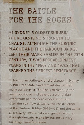
Sorry, this is so hard to read but it relays the era of the Green Bans, a series of worker boycotts of projects that would have destroyed many historically important sites in the city. Go to Sydney’s Green Bans: the worker boycotts that saved the city – Lives and Times (livesandtimesblog.com) to learn about this interesting time in Sydney's history.


This mural is along Kendall Lane.  Read the following photos to learn about it. 


From the mural we headed downhill into the back alley between Kendall Lane and George Street. 


See the plaque on the wall?


We cut through Unwin's Stores to George Street. Unwin's Stores is believed to be the longest continually occupied row of shops in Sydney and Australia. These five buildings were originally built as shops and dwellings between 1843 and 1846. 77-85 George Street.  

77 George Street, current location of The Doss House whiskey bar, has had many different uses.  Business located there have included a boot maker, a boarding house, and an opium dealer.

George Street looking downtown.

One of the rare addresses which make you think of the Harry Potter movies.

Cadmans Cottage is the second-oldest surviving residential building in Sydney, having been built in 1816 for the use of the governmental coxswains and their crews. It also claims the title of the first building to have been built on the shoreline of The Rocks area. It is claimed that during high tide, the water would come within 8 ft of Cadmans Cottage; however, due to the reclamation of land during the building of Circular Quay, the waterline has moved about 330 ft away since 1816.


This picture shows just how close the shore is and how deep the water must be.  Yes, that's a cruise ship. 

We saw some phone booths too.  Most didn't look like this; they just had an overhanging roof.  Not sure about this one, but the others offered wi-fi service. 

Rawson Institute For Seamen was formerly built (1856 to 1859) as The Mariner's Church. 
The following two websites give a more complete history of the building from its construction as a church to its recent use as a bar.
https://pastlivesofthenearfuture.com/2012/08/23/the-rawson-institute-for-seamenbar100-the-rocks-nsw/
http://www.shfa.nsw.gov.au/sydney-About_us-Our_heritage_role-Heritage_and_Conservation_Register.htm&objectid=91

Corner of George and Hickson, looking toward the Harbour Bridge. The buildings are the Campbell's Stores.  Their website has more information about them and a timeline of the area.  https://www.campbellsstores.com.au/history

Corner of George and Hickson, looking northwest on George Street.


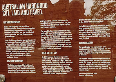
Section of the street paved with wooden blocks.

Very interesting information on why wood blocks were laid and what happened to them.  Actually, some are still under the asphalt.

Now that's a steep penalty. 

From George Street we walked up Mill Lane, where water ran alongside the steps.

At the top we could see where water gushed out of the pavement.  I never did find out about why this happens.

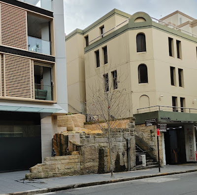
From the top of Mill Lane steps, we crossed Playfair street and went through a building to this courtyard in back.  Here you can see the natural stone cliffs for which The Rocks were named.  We learned a little of the history of this area.

Then we mounted the steps along the building we had come through.  They crossed over the gap to the top of the rocks.

On top looking back down. 

This area is called Foundation Park.  It's the location of the second wave of terrace house building in inner city Sydney in the 1880s on topographically difficult sites such as cliff edges, through which an extensive network of paths and steps provided pedestrian routes.  We stepped between the wall remnants where we were told about the layout of a typical terrace house and the difficulties of living on this narrow strip of hillside.

From Foundation Park we walked back to Argyle Street and took a right.  We went up the Argyle Steps, the oldest surviving steps in The Rocks, Go to The Rocks Website to read about them.  While you are there, read about the Argyle Cut, created to connect one side of the peninsula with the other.  The road crossing over Argyle Street is Cumberland, the road where the YHA is located.  We had come down the Argyle Steps earlier in the day on our way to the start of the walking tour 

We liked the red sign about racism.

Crosswalk signs are a bit different in Australia.


Another typical look of a pickup in Australia

Lovely garden area down by Circular Quay.  

A unique example of a nineteenth century Queen Anne Style hotel in the inner city, which features a picturesque Scottish baronial tower. The three-story hotel was built with roof shingles, rendered masonry external walls with decorative string courses and other moldings. The site was once part of the original Sydney Hospital. Go to The Rocks Website to read more about this historic building. 


This mural of Sydney environmental activist, Jack Mundey, was   created by artist Alexandre Farto aka Vhils.  It's located on the stairs leading up from Globe Street to Harrington Street.    It's hard to tell from this photo but it's actually in two parts.  The bottom is on the support wall for the first flight of steps while the top is on the support wall for the second flight of steps. 

Once we got on Harrington Street we had to take a short jog to the right to continue up some more steps.  On the rock wall to the left of the steps is a small statue. 

This sculpture, created by Leonie Rhodes, is called ‘Child of The Rocks’.


Old sandstone steps leading from Harrington Street to Cambridge Street. 


Before we headed up the Cumberland Steps, we were on Cambridge Street. 


The back of Susannah Place, a terrace of four houses built by Irish immigrants in 1844.  There is a guided tour of these homes that would have been interesting.  Check out their website at https://sydneylivingmuseums.com.au/susannah-place

We continued up the Cumberland Steps to Cumberland Street. 

And back to the YHA.  A note on the Whalers Arms.  It was a hotel in The Rocks.  You can read all about it at the following website, https://www.visitsydneyaustralia.com.au/rocks-pubs.html 


No comments: