
 |
| This is from the Viking Daily. We had watched the port talk on Santorini and found out some interesting things. |
 |
| This photo was taken from the TV screen as we watched the port talk. The red circle is where the tender will deliver us to the buses awaiting us. More on that later. You might have noticed the interesting shape of these islands and immediately identify that they are the sides of a volcano that blew off its top. This is the site of one of the largest volcanic eruptions in the past 10,000 years. It occurred in approximately 1620 BC on this volcanic island in the Aegean Sea. |
 |
| The circled town is Oia, pronounced E AH where some of the most iconic sights of the island can be found. Prior to 1620 BC, the island of Santorini, now known as Thera, was built up by layers of lava created by overlapping shield volcanoes, and it had experienced three significant eruptions that formed overlapping calderas, or collapsed magma chambers. Around 1620 BC, the fourth (and latest) major eruption created the present-day islands and caldera bay of Santorini Volcano. The caldera rim is clearly visible in this image as a steep cliff forming the western shoreline of the island of Thera. |

 |
| This map shows that the ship will anchor approximately where the green star is and we will get on a small tender to Athinios Port. At the end of our tour, we will board a cable car in Thira back to the Old Port where we will board another tender to deliver us back to the ship. Following the 1620 BC eruption, much of the previous island of Santorini was destroyed or submerged; this event may have been the inspiration for the legend of the “lost continent” of Atlantis. Far from legend however, many archeologists believe that the eruption was a major factor—or the immediate cause—of the destruction of the classical Minoan civilization of Crete. The white rooftops of cities and towns trace the caldera rim on the island of Thera, and overlook the young central islands of Nea Kameni and Palia Kameni, which both formed from lava domes and flows that started erupting approximately 1,4000 years after the cataclysmic 1620 BC event. The most recent volcanic activity in the Kameni islands occurred in 1950, and included some small explosions and production of lava. |
 |
| Beyond the ships is Thirasia Island. |
 |
| The volcanic nature of the island was readily apparent. |


 |
| Following the eruption in 1620 BC, some places on the remainder of the volcano were covered in as much as 130' of ash. This is what buried the prehistoric town of Akrotiri, where excavations began in 1967. |


 |
| Oia |
 |
| We boarded a tender and headed off for our tour. |
 |
| The tender was taking us to Athinios Port. What's hard to see in this photo is the road that switchbacks up the cliffside. |
 |
| Arriving at Athinios Port |
 |
| Maybe the road is easier to see in this photo since where are some vehicles on it. |
 |
| Anyway, we boarded a bus and started up the road. |
 |
| The turns were so sharp that the bus was literally crossways in the road at each one. |
 |
| Getting higher. |
 |
| If you double-click this photo, you might be able to see a vehicle on a lower turn in the road. |
 |
| As we got to the bottom of the ash layer, we could see holes carved into the rock. I found out that some of them are cave homes. Supposedly very upscale and expensive. |
 |
| There's a bus making one of the turns. |
 |
| Just about there. |
 |
| I've got to admit that most of the island wasn't very scenic. Here is a vineyard. That's right, the vines are up on ropes strung between posts. To protect the vines and their fruit from the brutal winds, no trellises are used. Instead the grapevines grow directly on the pulverized pumice, basalt, sand, and ash that make up the completely infertile soil of the desert island. To further protect the fruit, winegrowers use a particularly unique method of training the vines into a koulura, a coil of vines that sits directly on the ground and over time comes to resemble a basket. |
 |
| Despite the near total lack of rainfall, and harsh winds that buffet the island for many months, the vines and their root systems are able to pull enough captured moisture and minerals from the ash and porous volcanic rock to survive. |
 |
| We found out that ATV's are very popular on the island because we saw them everywhere. |
 |
| It was interesting to see a lot of land void of homes while other areas they practically lived on top of each other. |
 |
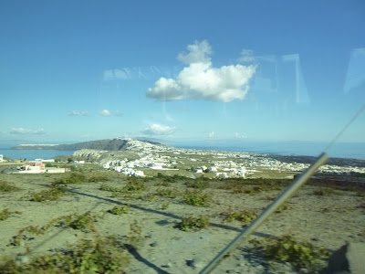
| The bus took us to the top of Mount Profitis Allas for the view. Here we can see the airport. The hill is also home to a monastery and a military facility. |
 |
| We can see Oia, our next stop, from here. |

 |
| These must be old grape vines as you can see how they are wound into a basket-like shape. |
 |
| These are so white I wonder if they are a new development. I thought the tour guide said there were regulation regarding new construction to make them adhere to a uniform look. The dominant white and blue colors of the Cycladic architecture are a symbol of Greece as they represent the colors of the Greek flag. |
 |
| Fuel (gas) is delivered to the island via ship. There's a pipe they hook up to to pump the fuel to the island. |
 |
| Interesting little harbor. |
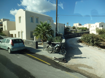 |
| Parking spots are at a premium in the towns so any spot will do. |
 |
| Saw these interesting trees and wondered what they were called. |
 |
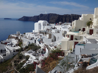
| We get off the bus in Oia and this is the main pedestrian throughfare. Lots of shops but Santorini's economy is 90% tourism based. |

 |
| Many of the paths were much smaller than this and consisted of a lot of steps. I saw some people with suitcases that had obviously been staying there. I definitely wouldn't recommend saying there unless you took very little with you because wrangling a suitcase on the steps of these narrow lanes would be very problematic |
 |
| Obviously you can't drive to these homes. I would hate to break a leg if I lived here! |


 |
| Iconic Santorini viewpoint |
 |
| Looking across the caldera to Thirasia Island |
 |
| Thirasia's port to town road |
 |
| After Oia, we ride back to Thira where we get a short tour and are show the path to the cable cars which will get us back to a port. |

 |
| The walk to the cable car was lined with shops. |


 |
| Here's our ride. |


 |
| Saw some old walls while headed down in the cable car. |

 |
| The wheel that makes the cable car run. |
 |
| Not our ship but I thought it made a pretty picture |
 |
| Tenders came in all shapes and sizes. Of course the sailors very experienced with the docking procedure. |
 |
| The ash layer is full of holes and I'm sure many of the are homes. |


No comments:
Post a Comment