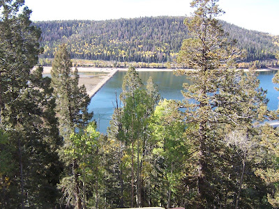
 Along Utah 14 on the way to Cedar Breaks, we saw Navajo Lake. Well first we just saw barren ground with small puddles of water then we came to this overlook. The sign at the overlook said this: The original lake was formed when lava flowed across the east end of the valley. After thousands of years, the lake still has no open outlet. Water leaves the valley through a series of sink holes and reappears at Cascade Falls and Duck Creek. Cascade Falls flows into the Virgin River. It is a part of the Colorado River Basin. Duck Creek feeds into the Seiver River which is a part of the Great Basin.
The dike across the lake was constructed in 1931 to provide adequate water for fisheries and water related recreation.


This area of Utah is known for its leaf colors in fall. The season is not quite at its peak but we did find some nice coloring.


What surprised me about the area is all the piles of what looked like lava. I didn't think this area had volcanos. See the following photos for an explanation.


...So that explains it.

View behind the sign.

More fall coloring.

...We did notice a lot of dead trees too. Looked like mostly evergreens.
 ....We bypassed the entrance to Cedar Breaks and continued toward Cedar City so we could check out the road. This is the way we are leaving the area with the truck and trailer. Along the way we found another overlook.


Info display along the side of the road leading into the park. Double click to enlarge so you can read about the lodges.
 Just look at those food prices!
  When we got out of the car at that info sign, my comb stuck out of the hole in my pocket and anchored itself to the seat! Time to put it in the left-hand pocket.
  The visitor center is at an elevation of 10,350'. Highest we had been for quite some time.
 Really this is like Bryce Canyon except on a smaller scale. String the following pictures together and you have a panoramic view.
..The park brochure says this: Shaped like a huge coliseum, the amphitheater is more than 2,000 feet deep and more than three miles in diameter. Millions of years of uplift and erosion caved this huge bowl in the steep west-facing side of the 10,000-foot-high Markagunt Plateau.


No comments:
Post a Comment