My husband and I kept hearing about how wonderful the museums were in Cody, Wyoming, so we decided to take a trip there. We visited friends along the way, so our trip started by heading north.
 |
| They also had a little yellow submarine on the property. |
 |
| Roadside end of the Little Golden Gate Bridge. After this stop, we headed further into Washington and stayed with friends for the night. The next day we headed to the Museum of Glass in Tacoma, WA. |
 |
| In the hallway leading to the bathrooms, they displayed drawings by children, ... |
 |
| And the Glass Shops rendition of the drawing. |
 |
| There were many cool works of art, but I liked this one the best. Then we were off to the gallery to see professional pieces of glasswork. |
 |
| This was one of my favorites. In person, it looked like velvet. |
 |
| This one is interesting because, depending which side you looked at... |
 |
| it could almost completely disappear. |
 |
| This one has some intricate little pieces. |
 |
| Check out the cellphone, glasses and computer. |
 |
| Check out all the small pieces of this work of art. |
 |
| The glass spider is an interesting detail. |
 |
| We stopped by the Hot Shop where they were making a large elbow.... yah, an elbow. Don't know if it was going to be part of a larger work of art or a standalone. |
 |
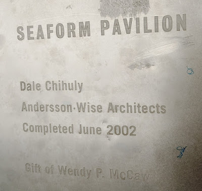
| After the museum, we went outside to check out the bridge of glass. The bridge isn't made of glass but there's a bunch of artwork by Dale Chihuly displayed. |
 |
| There are actually two glass displays, one in the cubbyholes in the side and one with the display overhead. |
 |
| Across the highway is the Old Union Station Train Station. It how houses a U.S. District Court and an event center. |
 |
| I-705 runs between The Musuem of Glass and Union Station. We got on it when we left. |
 |
| This is Wild Horse Monument by Vantage, WA. We were here in June of 2009 and hiked up the hill to check out the sculptures. |
 |
| The view from the parking lot shows the Vantage Bridge upon which I-90 crosses the Columbia River. Actually, at this point, it is Wanapum Lake formed by the Wanapum Dam just downstream. |
 |
| Just off I-90 at Ritzville you can see this stagecoach and team of horses all made out of horseshoes. |
 |
| The North Idaho Inn in Couer d'Alene sports an Idaho shaped chimney. |
 |
| Another roadsideamerica.com stop. Kellogg, ID |
 |
| Roadside memorial describing a mine disaster that happened in 1972. |
 |
| The memorial consisted of a statue with a listing of the victims. Around this were small commemorative markers listing men that had been killed in any of the state's mine disasters. |
 |
| Wallace is full of interesting items, including this spaceship. I wonder when it landed... |
 |
| Ok now here's a claim that can't be verified. |
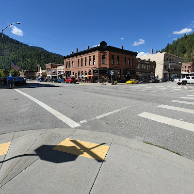 |
| There was a sign at each corner of this intersection, so I suppose the intersection is "The Center of the Universe". |
 |
| We've lived within 100 miles of the Missouri River for most of our lives, so we made a point of stopping at the Missouri Headwaters State Park. You can click on the photo to enlarge it for reading. |
 |
| From the ground it was really hard to see the confluence. There's a diagram further down in this post. |
 |
| The Gallatin River joins the Missouri about a mile from where the Jefferson and Madison merge. The Jefferson starts by Twin Bridges, MT and the Madison starts in Yellowstone National Park. |
 |
| Click to enlarge for reading. |
 |
| Just south of Red Lodge, MT we started into the Beartooth Range. |
 |
| We started climbing. |
 |
| First the road started making tighter turns until we came to the switchbacks. |
 |
| We could see two layers of the road across the side canyon. |
 |
| We even spotted some snow on the far side of the valley. |
 |
| Looking down on a couple meanders of the road. |
 |
| This isn't the top of the pass but it's the most developed vista point. |
 |
| The stop has a short walk to the vista point. |
 |
| Love how this tree grew out of the rock. I wonder how old it is. |
 |
| Looking up Rock Creek toward Wyoming. |
 |
| Looking back the way we came. |
 |
| Continuing up the mountain we gathered information as we stopped at viewpoints. |
 |
| With 20 peaks over 12,000' in elevation, the Beartooth Mountains lie within the 943,377-acre Absaroka-Beartooth Wilderness. |
 |
| The temperature dropped as we climbed. Somewhere along the way we passed the 45th Parallel, halfway between the equator and the North Pole. |
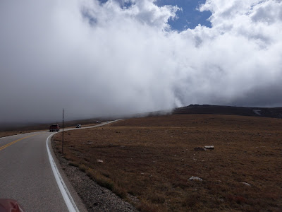 |
| We reached the clouds as we neared the top. I think this is the Hellroaring Plateau. |
 |
| We were definitely in the alpine zone as there weren't any trees. The stop at the top of the pass was full so we didn't stop. It was pretty cloudy so I doubt we could have seen anything anyway. |
 |
| The top of the pass is the world of glacial cirques and alpine lakes. There are over 950 alpine lakes. |
 |
| Lowest temperature we saw during our trip over the pass. A week after this trip, this area had a snowstorm, so we went at the right time. |
 |
| We saw what looked like the top of a cableway for skiing. Sure, enough they have a ski area called Beartooth Basin that is open to the public, dependent on snow, of course. |
 |
| The clouds obscured any sight of The Bear's Tooth, a pyramidal shaped spire that was carved by glaciation. It is the namesake of the Beartooth Mountains. |
 |
| Heading back down we start to see trees again. |
 |
| We encountered a few raindrops along the way. |
 |
| We left Beartooth Pass highway and headed toward Cody on Hwy 296, the Chief Joseph Scenic Byway. At this point, I had downloaded some stories about the area we could listen to as we drove. |
 |
| Pilot and Index Peaks are volcanic remnants more than 11,000 feet high. |
 |
| My question was this. Why didn't the U.S. government just let them run to Canada? |
 |
| This, and other, outcroppings of sandstone were confusing until I remembered that all this area was covered by an inland sea millions of years ago. |
 |
| Relief on a monument in front of the Park County Courthouse. |
 |
| Information on the relief. |
 |
| This sculpture is in front of the Park County Fire District Office. |
 |
| The most famous thing in the hotel is the cherry wood bar. It dates back to the original construction and was rumored to be a gift for the Queen of England. |
 |
| We turned down 12th street to take a gander at the Giant Parade Rifle... |
 |
| Novel design of logo for local pizza place. |
 |
| This was a guided tour with someone with us the whole time. |
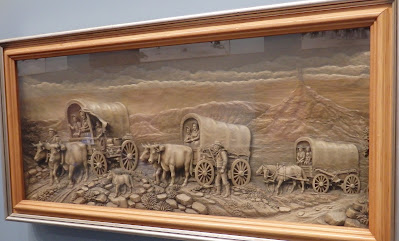 |
| Loved these wood relief wall hangings. |
 |
| Next we decided to head out to the Cody Dam. Along the way, we stopped to read this billboard and take in the sight. |
 |
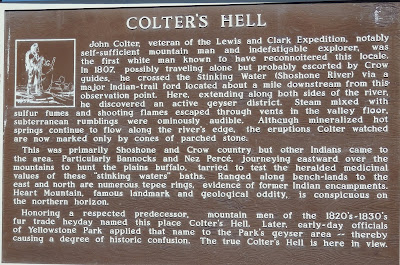
| This is the Shoshone River west of Cody, at the Colter's Hell stop. |
 |
| The highway follows the Shoshone River as it cuts into the Absaroka Mountain range. |
 |
| There's not room for both the road and the river so the road requires a tunnel. |
 |
| But there are three tunnels. Going into the first we could see the start and end of the second tunnel. |
 |
| Just after the third tunnel was a parking lot on the left for the Buffalo Bill Dam and Visitor Center. The river side of the parking lot had a bunch of information panels and some artifacts. |
 |
| You will have to click on this photo, and many of the following, in order to read them. |
 |
| Next photo is an enlargement of the narrative. |
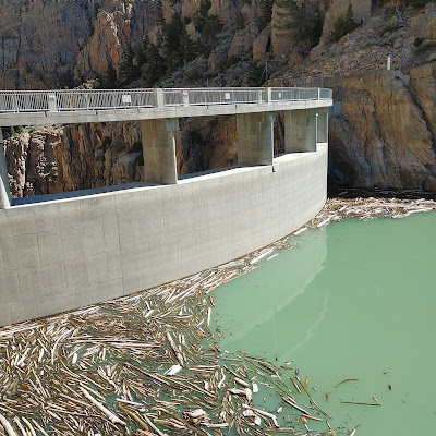 |
| The front side of the dam. |
 |
| The Buffalo Bill Reservoir widens once it gets past the narrow valley. |
 |
| Visitor Center and dam as we walked toward it. There is a golf cart shuttle between the parking lot and the visitor center. |
 |
| Looking down the face of the dam we noticed a platform hanging out over the far cliff face. |
 |
| It's a cableway landing platform. More on that later. |
 |
| Looking further downstream. |
 |
| There was another section of the visitor center that wasn't dam related. |
 |
| We headed to the left once we got inside, which meant we visited the Draper Natural History Museum first. |
 |
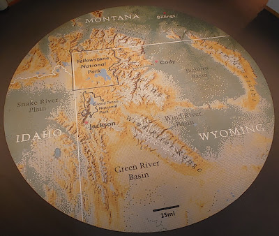
| Not natural history but something interesting about Heart Mountain, is that a Japanese American confinement site was once located east of the mountain. We've been to one of these internment camps in California called Manzanar. See that post to this blog under September of 2017. During World War II, Heart Mountain was one of many camps that were quicky built after President Franklin D. Roosevelt signed an executive order resulting in the forced removal of Japanese Americans from their homes. These U.S. citizens were given just a few days to sell what they could, pack a suitcase and leave their homes for the unknown. Can you imagine that? Say you own a business. Do you imagine you can find a buyer? These people lost their businesses and homes. Nearly 14,000 Japanese Americans were held at Heart Mountain. The entire town of Cody, just a few miles away, had a population that was smaller than that. The camps were hastily constructed. There were 467 barracks buildings situated in 20 blocks. Each tarpaper covered building was 120 feet long by 20 feet wide. Barracks were divided into six rooms of various sizes. Families of six were housed in 480 square foot rooms. Each room had a stove for heat and a light fixture in the center of the room. The camp operated for more than three years until it finally closed in November 1945 after the war was over. The government gave each resident of the camp $25 and a train ticket to anywhere they wanted to go. The camp was quickly disassembled. The government sold the barracks to the ranchers and other locals for just one dollar. many were used for storage on farms and ranches. |
 |
| We looked over a railing to see the mosaic on the floor below us. |
 |
| Wow I never thought about something like this. |
 |
| This would sure help fund the upkeep of the park. |

 |
| After a lunch break at the museum's dining room, we visited the Plains Indian Museum. |
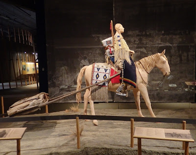 |
| Due to the wide variety of Native American skin tones, all sculptures are left in their natural clay color. This also helps highlight the items on display. |
 |
| I can't imagine how many hours it would take to do the beadwork on this saddle blanket. |
 |
| Wow, a beaded ballcap. |
 |
| Shields |
 |
| Elk Teeth |
 |
| I wonder how heavy this shirt is.... |
 |
| Moccasins decorated with dyed porcupine quills. |
 |
| Moccasins decorated with glass beads. |
 |
| I love inlay work and this horn has a lot of it. |
 |
| A true work of art. |
 |
| We ended our first day at the Whitney Western Art Museum. |
 |
| I don't know what it weighs but there's only six hooves touching the ground. |
 |
| Even I have see this one before. |
 |
| Another famous sculpture |
 |
| Plaster cast of Rough Rider sculpture. |
 |
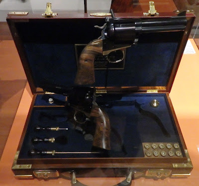
| We started day two of our visit at the Cody Firearms Museum. |
 |
| For someone like me, who doesn't know much about guns, there was a gun 101 section. |
 |
| Now this is a tiny pistol. It's in the middle of the display below. |
 |
| Can you see it? |
 |
| Gees, let's have a weapon that does everything. |
 |
| I've never seen anything quite like this gun. |
 |
| I think the middle gun is over 6' long. |
 |
| They had a small mock-up of a factory in the museum |
 |
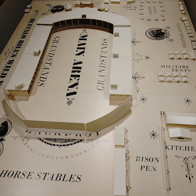
| Last museum was the Buffalo Bill Museum. I was surprised when the first few displays weren't even about Buffalo Bill but about other famous people of the time. |
 |
| Annie Oakley's suit. |
 |
| Steam fumaroles are common. |
 |
| Looking across the lake, we could see more fumaroles. |
 |
| Remember, you can click on the photo to enlarge it for reading. |
 |
| Cliff geyser was just steaming. |
 |
| Ragged Spring. |
 |
| Rainbow pool |
 |
| What are those black dots? |
 |
| We stopped to eat lunch along the Firehole River. |
 |
| The scenery was different across the road. |
 |
| Once at Madison junction, we turned left and followed the Madison River out of the park. The Madison is one of the rivers that combine to form the Missouri. |
 |
| I think this is Mount Haynes. At West Yellowstone, back in Montana, we followed Hwy 20 for the rest of the day. |
 |
| Hwy 20 quickly lead us out of Monana and into Idaho. We crossed over the Henry's Fork River at least three times before the day was over. |
 |
| Henry's Fork River. |
 |
| This sounded interesting and we had the time so we decided to investigate. |
 |
| A sign said the road was rough, and it was right at the beginning, but they it smoothed out... for about a mile anyway. Then it got really rough so we turned around. |
 |
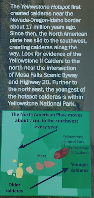
| The last sightseeing we did that day was a trip to Mesa Falls. This is a map of the Upper Mesa Falls area. We walked trails, descended stairs and walked on a boardwalk to get to the falls. |
 |
| Yep, that's the Henry's Fork again. |
 |
| We had descended some steps but it looks like we had more to go before we could follow the boardwalk to the falls. |
 |
| Upper Mesa Falls |
 |
| Mist rising through the air at the top of the falls. |
 |
| Time to climb back to the upper boardwalk. |
 |
| Next stop, Lower Mesa Falls. These were quite a distance from the viewpoint. |
 |
| Heading on down the road, we stopped to read this information panel. |
 |
| The next day we continued our journey on Hwy 20 to Idaho Falls where we stopped to see this sculpture in the middle of a roundabout. |
 |
| Continuing west on Hwy 20, we entered a pretty desolate area. |
 |
| East Butte |
 |
| Middle Butte |
 |
| Southern Butte |
 |
| The Big Lost River Rest Area had a bunch of information panels. Below you will find photos taken of each section of this panel |
 |
| We wanted to visit EBR-1, the world's first nuclear power plant but it had just closed for the season. |
 |
| Continuing west, we took a break at the Castle Rock pull-off. |
 |
| Further west we stopped a pull-off and read this interesting sign. |
 |
| We made it back into Oregon and stopped north of Bend. |
 |
| The only problem is that there are some large fires in eastern Oregon so the view of the Sisters was obscured. |
 |
| We continued on Hwy 20 to Sisters, Oregon where we turned onto the McKenzie Hwy which is closed from November to July. |
 |
| The road got narrower as we climbed and we ran into a large area that had burned in years past. |
 |
| Then we were winding through lava fields. The road was terrible in places but there were plenty of motorcyclists enjoying the curves. |
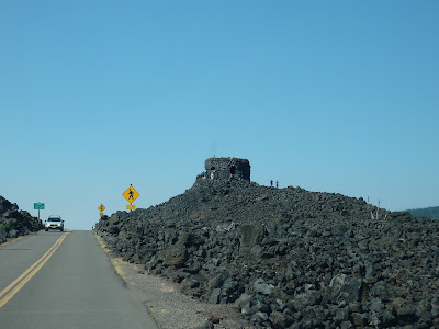 |
| The Dee Wright Observatory is at the top of the pass. |
 |
| Time to climb to the top. |
 |
| You definitely had to watch where you stepped. |
 |
| Looking toward North Sister, South Sister and Broken Top |
 |
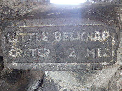
| The interior portion of the structure had viewpoint, so you know what you were looking at. Belknap Crater is 2.7 miles away. |
 |
| Belknap Crater |
 |
| Little Belknap Crater is 2 miles away. |
 |
| Mt Washington is 5.2 miles away. There were more viewports, but their inscriptions were too hard to read. |
 |
| Next, we climbed to the top of the observatory where this pillar heap a bronze cap that was inscribed with the names of various features with arrows indicating which direction to look. |
 |
| There was a trail leading off into the lava field. One viewpoint had information panels. |
 |
| We continued west down the pass and closer to the fires. |
 |
| We saw a fire service encampment once we passed west of the fire area. We missed getting a photo of the large helicopters and equipment. |




























No comments:
Post a Comment