|
| Harper Corner Road is the second entrance we took into Dinosaur National Park. It's really funny because we started out in Colorado but the road took us back into Utah before ending in Colorado. Most of the road is not actually in Dinosaur National Park. |
 |
| We went clear to the end so we could look out over the confluence of the Yampa and Green Rivers on the east side of Steamboat Rock. |
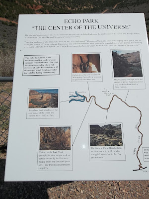 |
| On the way north we stopped at an overlook for the Echo Park Road. Passenger cars are advised not to take this road so we didn't. |
 |
| The start of Echo Park Road. |
 |
| The first overlook where we could actually see the Yampa River. |
 |
| The view to the right of the previous photo. |
 |
| I wondered how old this juniper tree was. It was sure a twisted mess. |
 |
| Sound like there was a lot of controversy on whether or not to build a dam in the canyon. |
 |
| We made it to the end of the road and it was time to walk the trail. It was a two-mile round trip. |
 |
| Through the juniper and pinon pine we went. |
 |
| Another large, dead, twisted tree. |
 |
| You might have to zoom in (click on the photo) to see the tiny circle of purple flowers. We saw lots of these at one of the overlooks. The cow mature provides the fertile spot around which the flowers bloom. |
 |
| Just another trail view. |
 |
| We saw this outcropping of rocks ahead of us and wondered if that was where we were headed. It was except that we didn't get to go quite that far out on the point. |
 |
| Rafters on the river far below us. We heard them scream as they went over one rapid. |
 |
| View of the Green River after it rounded the point. |
 |
| I was disappointed that we couldn't actually see the confluence of the two rivers once we got to the point. Steamboat Rock blocks the view. You can see the Green River off to the left (might have to click to enlarge photo) and the Yampa on the right. They come together on the other side of Steamboat Rock and you can see the Green River, after the confluence, at the bottom of the photo. We would have had to drive the Echo Park Road in order to see the confluence. This is where a Jeep would have come in handy. |
 |
| Looking back down the trail from the end. I could see a spot that I thought was the parking lot but failed to bring the binoculars with on this trip so I couldn't verify it. |
 |
| Another view of the Green River as it heads downstream. |
 |
| The Green River both before and after the confluence. |
 |
| I saw this sage bush growing out of a rock along the trail and called it my bonsai tree. |
 |
| When we got back to the parking lot, I got the binoculars out of the car and checked out the point where we had hiked. The trail was one mile one way. |
 |
| We headed back south on Harper Corner Road and stopped to hike this short trail. I was hoping to find something telling about the origins of the name but I didn't find anything. |


 |
| A view along Plug Hat Trail. |